Claudius Ptolemy, writing in the second century AD, listed a place called Claudivium. He gave it coordinates. He noted a river flowing in from the north. And then, for the best part of two thousand years, that was the sum of what the surviving record had to say about it. Later sources do not mention it. A name, a pair of numbers, and a silence.
The researchers call the discovery at Stein, in the municipality of St. Pantaleon-Erla in Lower Austria, a sensational find. Ptolemy's coordinates for Claudivium fit a site known to local scholars since the 1970s, where an auxiliary fort was identified in 2017. What geophysics has now revealed beneath the surrounding fields is something else entirely: a planned city.
What the ground shows
The geophysical data, collected by GeoSphere Austria, show a settlement area of 25 to 30 hectares laid out on a regular street grid, with an amphitheatre sized for approximately 8,000 spectators. Gerald Grabherr, an archaeologist at the University of Innsbruck, notes that this matches the amphitheatre of the military town at Carnuntum. He describes a settlement of this scale and planning beside an auxiliary fort of roughly 500 soldiers as, to date, without parallel in the Roman Empire. Forts normally attracted civilian settlements to supply the garrison. This one was drawn on a drawing board, and in plan it sits alongside the self-governing Roman towns of the province of Noricum.
The occupation window is narrow by Roman standards: roughly 80 AD to 180 AD. Barbara Kainrath of Research Archaeology, who co-directs the fieldwork with Grabherr, is direct about what the end looks like. The finds point to a planned withdrawal around 180 AD. There is no evidence, she says, that the settlement was destroyed.
The methods, and why two were needed
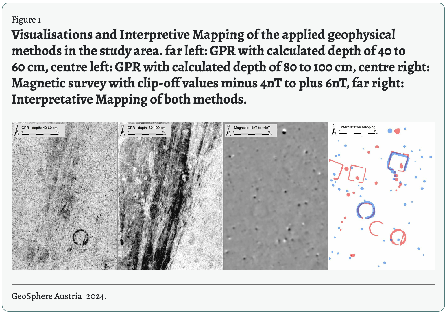
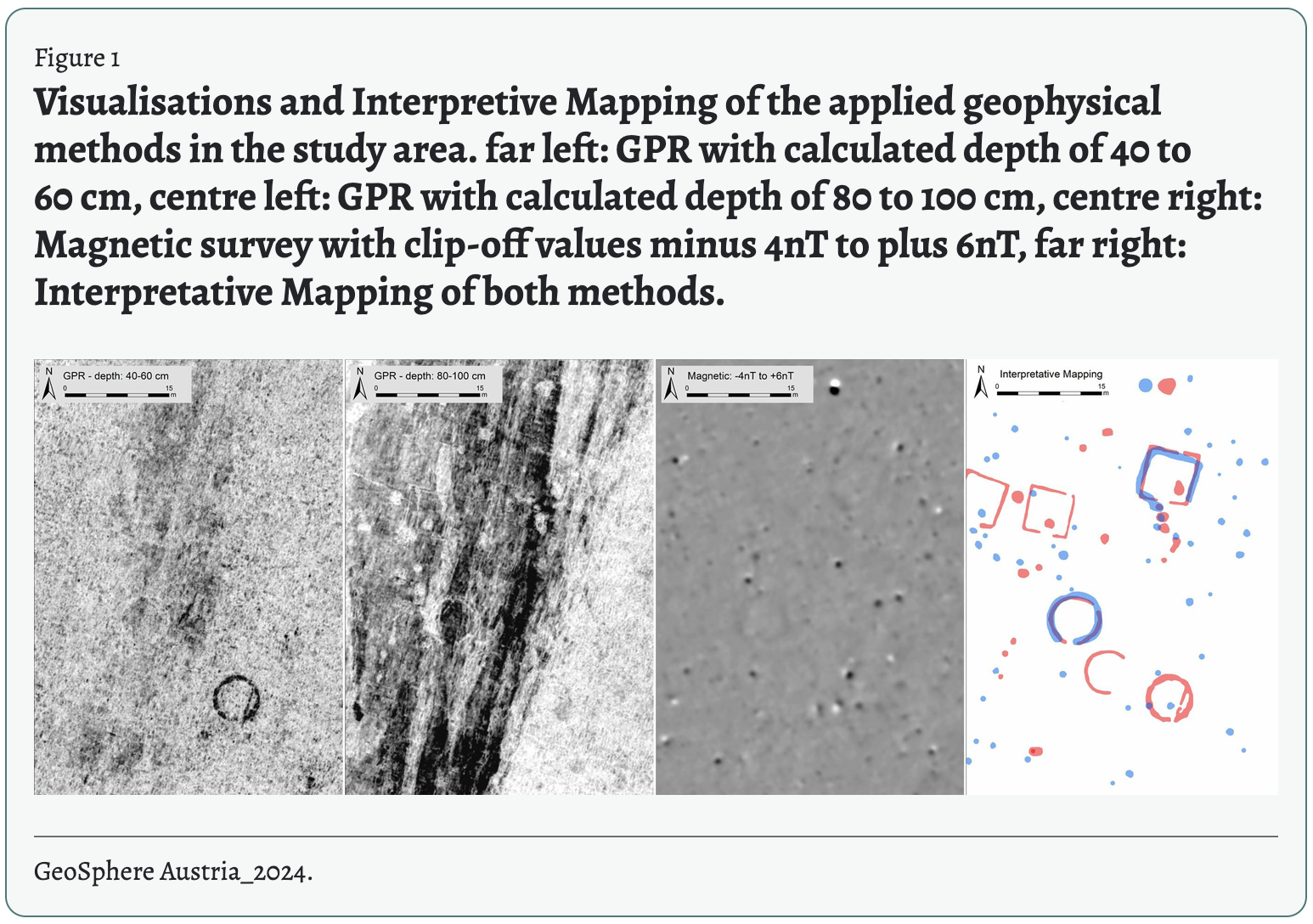
The geology at Stein is what made the discovery difficult. The site sits on fluvial gravels and sands laid down by the Enns, which flows from the pre-Alpine foothills, under only a thin layer of topsoil. These deposits change composition abruptly, so different geophysical methods showed individual structures with very different clarity.
The solution was combination. Over three years, a continuous area of approximately 100 hectares was surveyed with motorised magnetometer systems (eight Förster FEREX fluxgate probes pulled by quad bike, at 25 cm spacing). Separately, ground-penetrating radar (a MALÅ MIRA HDR multi-channel system with 500 MHz antennas) was run over approximately 50 hectares, reaching a calculated depth of 2.5 to 3 metres. Neither method alone gave a complete picture. Overlaying the two datasets in a joint interpretive map is what produced the street grid, the insulae (residential blocks) and the amphitheatre outline.
The Claudivium question
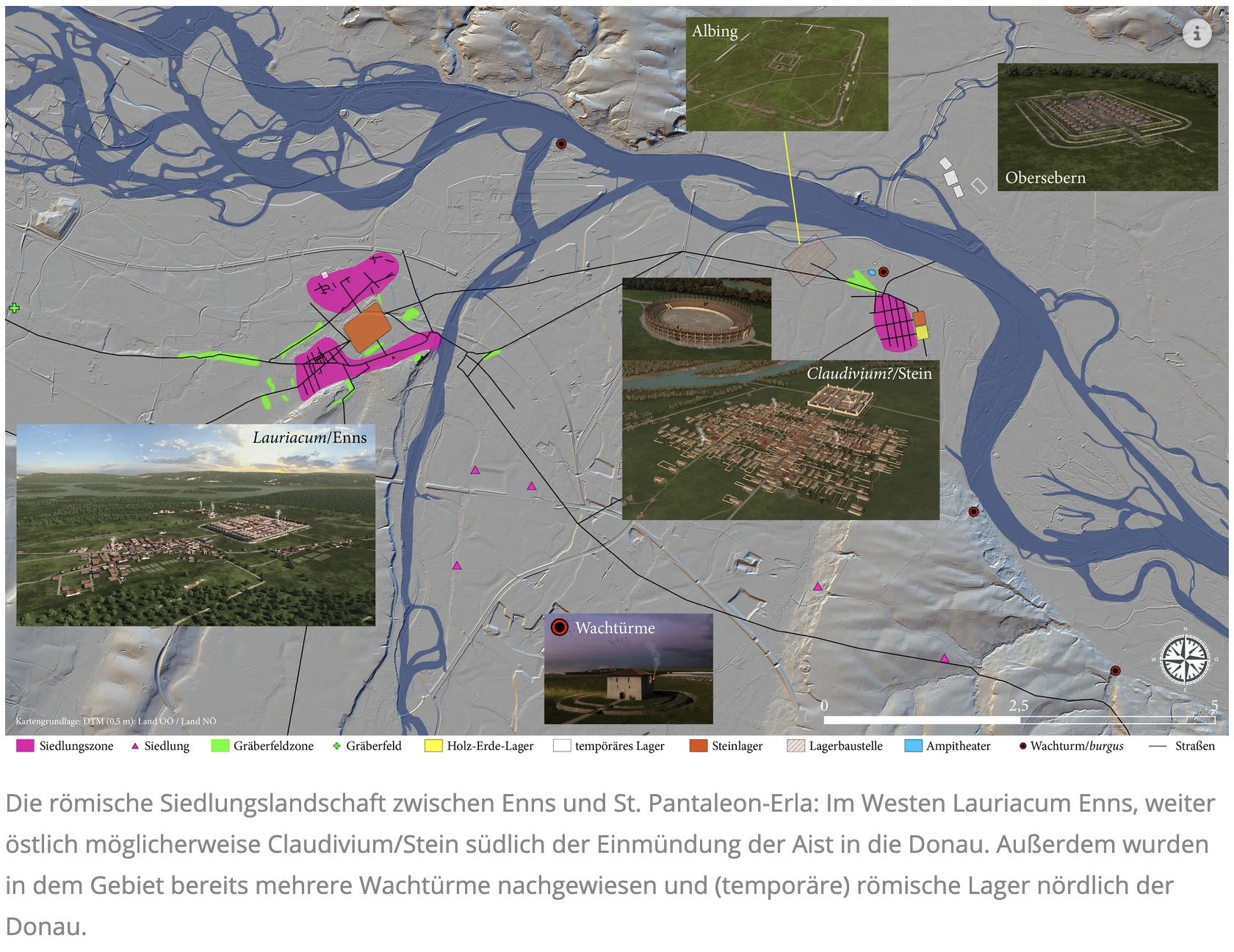
The identification of the site as Claudivium is a hypothesis, not a confirmation. It rests on two things: Ptolemy's coordinates, which fit the settlement at Stein, and his note of a river entering from the north at the same point. That river could be the Aist, which joins the Danube just north of the site. No inscription naming the town has been found. The paper's authors put it carefully: "perhaps it is Claudivium? as mentioned in historical sources, a town that was nearly forgotten in antiquity."
The question mark is doing real work. The coins date the end of occupation to around 180 AD, which would explain why later sources drop the name. But consistency is not confirmation, and a second-century geographer's coordinates are a good lead rather than a signed statement. Until something turns up with the name on it, Stein is "possibly Claudivium", and this post uses the name on that basis.
Why the city was abandoned
The coin sequence, approximately 643 coins recovered from the site, places the end of occupation at the change of emperor from Marcus Aurelius to his son Commodus. The strategic context is legible. The Marcomannic Wars, fought since 166 AD, were ended by a peace settlement under Commodus, and what followed was a fundamental reorientation of the Danube frontier's defence.
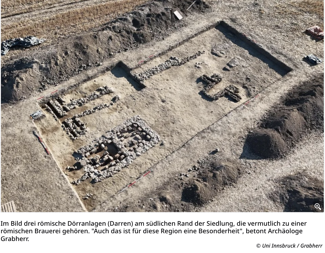
In that reorientation, Rome based legio II Italica at the more defensible Lauriacum, on the Enns six kilometres to the west, and gave up Stein. The people did not go far. Bronze-casting tools and the same types of fibulae (clothing pins) found at Stein have been recovered at Enns, indicating that craftsmen and residents moved their workshops westward. Lauriacum entered its heyday. Fifty years after the move it was approximately three times the size of the abandoned city.
Stein itself was put to a new use: it became a quarry. A planned city with an 8,000-seat amphitheatre, recycled as a source of building stone within a generation or two. Roman town planning was ambitious; Roman salvage was more ambitious still.
There is a second unfinished story a short distance away. At Albing, also within St. Pantaleon-Erla, lies the building site of a legionary fortress: foundation trenches and, in places, massive foundations for the defences and headquarters building, but no walls were ever raised. The fortress was never completed.
What was known before
The site was not, strictly speaking, unknown. Maximilian von Groller-Mildensee investigated the area in 1906 and 1910, but his finds were attributed to the nearby fortress at Albing. Local scholars have walked the fields since the 1970s, and fifty years of surface collection produced roughly 2,000 metal objects and 150 fragments of terra sigillata, enough to date the site but not to map it. In 2017 vegetation marks in a field gave away the corner of a second-century stone auxiliary fort at Stein, and later geophysical survey revealed an earlier first-century timber-and-earth camp on the same military site. What those finds did not reveal was the city: the 25-to-30-hectare planned settlement with its street grid, residential blocks, amphitheatre, and a large cemetery in the northwest whose tombs and burial mounds are big enough to suggest wealthy occupants. That is what the combined radar and magnetometry programme, running since 2021, has added to the record.
The site's strategic logic is clear from its position. It sits east of the Enns, controlling a Danube crossing at the mouth of the Aist. The Aist valley was one of the shortest routes between the Danube and the Vltava (Moldau), and therefore a key corridor for trade beyond the empire's northern frontier. Three to four temporary Roman camps have been identified north of the Danube in the same area, suggesting a concentration of troops at a time when Rome was eyeing Marcomannic territory for conquest.
The research programme and what remains
The discovery is the product of a research programme running since 2015 along a roughly ten-kilometre stretch of the Danube frontier between Enns (Upper Austria) and St. Pantaleon-Erla (Lower Austria). The partners are the University of Innsbruck, the Forum Donaulimes, GeoSphere Austria, the research firm Research Archaeology, and the state archaeology services of Upper and Lower Austria. Since 2021, the Danube Limes in this region has been part of the UNESCO World Heritage site "Frontiers of the Roman Empire".
The paper's authors open with a question that frames the significance: "How often does it happen that a completely unknown Roman town gets discovered in Central Europe?" The answer, it turns out, is not often, and not cheaply. Kainrath and Grabherr note that despite the region's significance, medium- and long-term funding sufficient for investigation to international standards has not yet been secured. The city has been found. The work of reading it is still ahead.
Sources
Grabherr, G. and Kainrath, B. (2024) 'Das Hippodamische Strassensystem im Lagerdorf des Auxilliarkastells in Stein/St. Pantaleon-Erla', in J. Horvat, S. Groh, K. Strobel and M. Belak (eds) Roman urban landscape, towns and minor settlements from Aquileia to the Danube, Opera Instituti Archaeologici Sloveniae 47, Ljubljana, pp. 317–326. doi: 10.3986/9789610508281_16.
Traxler, S., Thysell, E., Klammer, J., Kainrath, B. and Grabherr, G. (2024) 'Circum Lauriacum. Forschungen zum zentralen Knotenpunkt am norischen Donaulimes', in J. Horvat, S. Groh, K. Strobel and M. Belak (eds) Roman urban landscape, towns and minor settlements from Aquileia to the Danube, Opera Instituti Archaeologici Sloveniae 47, Ljubljana, pp. 307–315.
Universität Innsbruck (2026) 'Die vergessene Stadt: Roms Netzwerk beiderseits der Enns', Universität Innsbruck Newsroom, 25 September 2026. Available at: https://www.uibk.ac.at/de/newsroom/2026/die-vergessene-stadt-roms-netzwerk-beiderseits-der-enns/ (Accessed: 26 September 2026).
Wallner, M., Löcker, K., Hinterleitner, A., Gallistl, J., Schiel, H., Schlögel, I., Totschnig, R., Trausmuth-Wallner, T., Traxler, S., Thysell, E., Grabherr, G., Kainrath, B., Klammer, J., Hemmers, C. and Pollhammer, E. (2025) 'Claudivium? – How to discover a new Roman town?', ArchéoSciences, 49(1), pp. 219–222. Published online 15 September 2025. doi: 10.4000/14nru.
Wikipedia (2026) 'Kastell St. Pantaleon-Stein'. Available at: https://de.wikipedia.org/wiki/Kastell_St._Pantaleon-Stein (Accessed: 28 September 2026).